Friday, February 19, 2010
Earth Science
ROLE OF MAP LITERACY IN ENVIRONMENTAL EDUCATION
Tuesday, August 25, 2009
Maps are defined as a two dimensional, geometrically accurate representation of a three dimensional space. It is graphic representation of a set of features whose relationships are shown by size, position and time. Map is a tool by which we can view, measure and understand our environment. Map is one of the easiest tools and probably the best tool for establishing any environmental dialogue. It has generally been observed that the basic knowledge about maps is rather low among the people of this country, even among the formally educated. Map learning can make people able to handle geo-environmental information of local, regional, national and global levels efficiently and more accurately. Science Communicators’ forum, a Kolkata based NGO is pursuing map literacy programme in West Bengal since 2004. The organisation had implemented map literacy programme in 40 rural schools of West Bengal where 3000 students were given training on understanding, using, updating and creating maps of their local area. The exercises had given them a better idea and understanding of their local environment. They learnt how to observe the changes that occurred in terms of demography, social pattern, natural resource, pollution and biodiversity. Environmental mapping programme can be a part of environmental education where the learners will learn to prepare local area thematic maps based on different environment related themes and develop local environmental database. In an advance stage of map learning other geo-informatics tools like GPS, remote sensing and GIS may be introduced. A systematic curriculum can be prepared
Posted by Jadavpur Centre for Study of Earth Science at 6:55 PM 1 comments
Labels: education, environment, literacy, map
Does groundwater respond to solar eclipse?
Monday, July 20, 2009
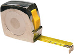
In the year 1980, during the total solar eclipse I conducted some experiments in the unconfined aquifer of Jalpaiguri district of West Bengal, India. The study was conducted in open dug well of depth of about 10 metres. Depth to water level measurements started one our before the start of the eclipse and completed after one our after the end of the eclipse. Water level had actually risen by 15 to 16 centimeters during the peak of the eclipse. Though the total eclipse was not visible at Jalpaiguri the groundwater appeared to respond to this astronomical phenomenon.In the year 1995 there was another total eclipse, which was visible from South 24 Parganas of West Bengal. I along with my colleagues of SWID selected one observation station at Falta where we desired to take water level measurements from very deep and moderately deep tube wells. We started taking measurements at 5 minutes interval from the wells using metallic tapes. We observed the rise of water level during the eclipse and found that the maximum water level rise was achieved at the time of totality. What was actually remarkable that the water level of deeper well rose by 34 cm whereas in the shallower well water level rose by 10 centimetres only.This year on 22nd July the members of JCSES are going to conduct similar experiments in Jalpaiguri district. They will conduct water level measurements from dug wells for 24 hours starting from 21st July evening.
Posted by Jadavpur Centre for Study of Earth Science at 7:04 PM 0 comments
Labels: 22nd July, groundwater, Jalpaiguri, total solar eclipse
CONCEPTS ON WATER FOOTPRINT AND VIRTUAL WATER
Friday, June 26, 2009
Pradip K SenguptaWater footprint is a new concept in the field of water management. It is expected that if water consumption or need of a country is assessed on the basis of water footprint an efficient water management practice can be achieved. To allocate water in individual sectors and for finding political solutions of a water conflict water footprint and virtual water can contribute a lot. The concept of water footprint is introduced recently at the beginning of this century. The concept was originally launched by A.Y. Hoekstra in the year 2002. A document on water footprint has been released by the UNESCO-IHE in 2002. In that document an attempt was made to assess the water footprint of individual nations. But what is a water foot print? Water footprint is a consumption based indicator of water use. The water footprint of an individual, business or nation is defined as the total volume of freshwater that is used to produce the foods and services consumed by the individual, business or nation. A water footprint is generally expressed in terms of the volume of water use per year. The calculation of water footprint is based on the amount of agriculture product, meat, industrial product and raw water consumed by an individual, business or nation.Each product, whether agricultural or industrial consume some amount of water in the production process. In agriculture water is consumed from soil, and lost through evapo-transpiration. Similarly when meat is produced water requirement is increased because water is consumed by the animal through fodder and direct utilization of water.The water footprint of a country (NWFP) has two parts. One is the internal water footprint (IWFP) and another is the external water footprint (EWFP).The internal water footprint of a nation is the volume of water used from domestic water resources to produce the goods and services consumed by the inhabitants of the country. The external water footprint of a country is the volume of water used in other countries to produce goods and services imported and consumed by the inhabitants of the country.So NWFP=IWFP+EWFPIn order to promote sustainable, fair and efficient use of water on a global scale seven global groups have launched the Water Footprint Network in October, 2008. Their aim is to work toward a common approach to water footprint measurement, accounting, and reporting. Partners of this group are the World Business Council for Sustainable Development, the University of Twente in the Netherlands, WWF, UNESCO-IHE Institute for Water Education, the Water Neutral Foundation, the International Finance Corporation (part of the World Bank Group); and the Netherlands Water Partnership.India has the largest water footprint in the world (987 Gm3/yr) but it also has a very high national self-sufficiency ratio (98%), The total which implies that at present India is only little dependent on the import of virtual water from other countries to meet its national demands. Whereas Bangladesh has its renewable water resource to the tune ofVIRTUAL WATERThe water required for production of a commodity, good or service is called virtual water. This means that the amount of water required for producing a unit amount of that product is the virtual water of that product. So when we consume anything we are actually consuming the virtual water for that product. The concept of virtual water was introduced by Professor John Allan of King’s College, London, in 1997 as an economic tool and an alternative means of measuring the global distribution of water through trade and was awarded the 2008 Stockholm Water Prize for it. In the past the in place of virtual water the term embedded water was in use. But virtual water has gained interest of the scientists and the term is now accepted as a term used for measuring the environmental cost in terms of water. In the same way trade of a commodity or service may be translated as the trade of virtual water.The virtual water of an agricultural product in a country may be different from that of the same product produced in a different country. For example tomato produced in USA contains less virtual water than tomato produced in Israel. This happens due to the difference in climatic condition between those countries. It is becoming evident that some water scarce countries will likely import food that is water intensive to produce.To determine the virtual water use we need data on crop water requirements over the growing season, evapotranspiration rates, the annual yield and the amount of water used in processing the crop.( Hans Schreier, Les Lavkulich and Sandra Brown May 2007) .The concept of Virtual Water should be an additional consideration in all water balance calculations.The virtual water content of different food products in India. (afterVijay Kumar* and Sharad K. Jain2007)Product Virtual water (cubic m/tonne)Agricultural ProductWheat 1654Rice (paddy) 2850Mustard oil 4643Maize 1937Banana 415Orange 364Sugarcane 159Grapefruit 411Lentils 6652Apple 1812Soybeans 4124Pear 1287Jute 2823Cotton lint 18694Potatoes 213Tomato 302Coffee (roasted) 14500Tea (green) 1804Sugar (refined) 1391Groundnut oil 8875Product Virtual water (cubic m/tonne)Livestock and livestock productsBovine meat 7386Milk powder 6368Swine 4119Yogurt/milk product 1592Sheep 3397Buttermilk 2068Goat 3018Cheese 6793Fowl/poultry 6024Egg (birds) 7531Leather (bovine) 17710Virtual water trade is another concept that can be related to trade of commodities.The virtual water consumption of a country can therefore be = domestic virtual water+ imported virtual water- exported virtual water.If the virtual water import is higher than the export then the country is a water importer. Virtual water may become an additional consideration in deciding what to export/import. This concept can be useful in making agricultural choices within the country among various states. But this new concept has not yet been used in decision making processes in most areas. It may also be added that for evolving water management policies, the concept of virtual water has to be used along with other aspects such as hydrology, geology, agriculture, engineering, land use, culture etc. It is not advisable that all decisions on water allocation should be based solely on virtual water assessment. At the global level, virtual water trade has geo-political implications: it induces dependencies between countries. Therefore, it can be regarded either as a stimulant for co-operation and peace or a reason for potential conflict.SOURCEShttp://news.moe.org.ir/vdce.z8xbjh8f7k1ij.html%2020_6_09Chapagain, A. K. and Hoekstra, A. Y. (2003). Virtual water flows between nations in relation to trade in livestock and livestock products. Value of Water Research Report Series No. 13, UNESCO-IHE Institute for Water Education, Delft, The Netherlands.Real and Virtual Water and Water Footprints:A Comparison between the Lower Fraser Valley and the Okanagan Basin Hans Schreier, Les Lavkulich and Sandra Brown, Final Report for the Walter and Duncan Gordon Foundation May 2007Virtual water trade … iran http://news.moe.org.ir/vdce.z8xbjh8f7k1ij.html%2017th%20may%202009Vijay Kumar* and Sharad K. Jain, CURRENT SCIENCE, VOL. 93, NO. 8, 25 OCTOBER 2007
Posted by Jadavpur Centre for Study of Earth Science at 9:06 PM 0 comments
Labels: india, UNESCO-IHE, virtual water, virtual water trade, water footprint, water trase
Governing Body of JCSES
Monday, February 2, 2009
President: Asitava DattaSecretary: Sibabrata Basu RoyTreasurer: Ruma BhattacharyaVice President: Amitabha Sengupta
Posted by Jadavpur Centre for Study of Earth Science at 9:42 PM 0 comments
Funds for NGOs.org: EC Call for Proposals: NGO, Civil Society, Local Authorities Capacity-building
Tuesday, January 20, 2009
Funds for NGOs.org: EC Call for Proposals: NGO, Civil Society, Local Authorities Capacity-building
Posted by Jadavpur Centre for Study of Earth Science at 9:12 AM 0 comments
Funds for NGOs.org: Multilateral Funds for NGOs
Funds for NGOs.org: Multilateral Funds for NGOs
Posted by Jadavpur Centre for Study of Earth Science at 9:10 AM 0 comments
Older Posts
Source
Subscribe to:
Post Comments (Atom)


.jpg)


.jpg)
.jpg)


.jpg)

.jpg)


)
.jpg)


.jpg)


.jpg)

.jpg)


.jpg)


.jpg)


.jpg)


.jpg)


No comments:
Post a Comment